


ABOUT US
With over a decade of hands on experience in drone based aerial data solutions. We are Based in the Western Cape and service clients across South Africa and take on specialized projects throughout Africa. We specialize in LiDAR surveying, mapping, 3D models, structural and pipeline inspections, aerial surveillance, aerial photography, game counting, bathymetric terrain analysis, and renewable energy assessments for wind and solar farms. We’ve supported critical missions like anti-poaching and search and rescue, operating in some of Africa’s most remote and challenging terrains, capturing over 3,000 hectares of LiDAR data. Backed by deep technical expertise and a proven track record, we help clients work smarter, safer, and faster with reliable geospatial data they can trust.
OUR CLIENTS
.png)


Book a site visit
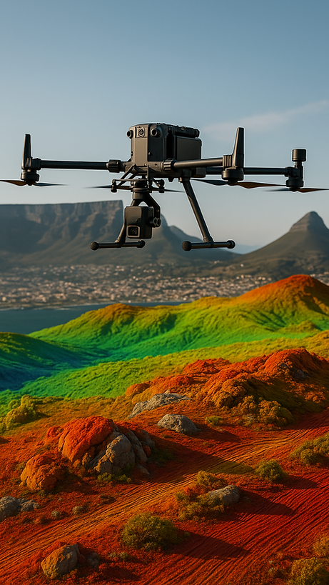
Our Expertise
LiDAR Survey & Mapping
At Sky Cru, we use advanced drone mounted LiDAR technology to capture high resolution 3D geospatial data across all terrain types including dense forests, mountainous regions, and rugged landscapes. Our aerial LiDAR surveying services deliver highly accurate elevation models, contour maps, and terrain analysis essential for effective planning and decision making in the mining, construction, agriculture, and environmental sectors. Clients across South Africa and Africa trust our LiDAR drone mapping for fast, reliable, and actionable data that improves efficiency, safety, and project outcomes.

Drone Structural Inspections
We specialize in drone based structural inspections for both ongoing maintenance and new construction projects. Using high resolution aerial imagery and advanced data analysis tools, we deliver detailed visual reports that detect potential issues early helping ensure safety, compliance, and project efficiency. Our construction progress monitoring services include weekly drone inspections that give clients a clear, consistent view of site development. This improves on-site communication, boosts accountability, and supports faster, more informed decision making throughout every stage of the project.

3D Mapping & Modeling
3D mapping and modeling is one of our core capabilities, enabling us to create highly accurate, photorealistic digital representations of real world environments. Using drone captured imagery we generate detailed 3D models ideal for planning, design, analysis, and presentation. Whether it’s a mine site, construction area, or natural landscape, our 3D models give clients valuable spatial context and measurable insights helping them visualize, assess, and manage projects with greater confidence and precision.

Powerline Inspections
Using drones equipped with high-resolution cameras and thermal sensors, we inspect powerlines, towers, and surrounding vegetation quickly and safely without the need for manual climbing or shutdowns. Our inspections help identify issues like damaged components, overheating, or encroaching vegetation early, reducing downtime and maintenance costs. We deliver clear, actionable reports to support informed decision-making and proactive maintenance.

Wind Turbine & Solar Farm Inspections
For wind turbines, we capture high-resolution imagery of blades, towers, and nacelles to detect cracks, erosion, or structural damage—without the need for risky manual inspections. For solar farms, we use both visual and thermal imaging to identify faulty panels, hotspots, and electrical issues. Our detailed reports enable proactive maintenance, minimize downtime, and ensure optimal performance and energy output across your renewable assets.

Bathymetric Survey
Bathymetric surveying is one of our specialized services, focused on accurately mapping underwater terrain using drone-assisted sonar and GPS technology. This method allows us to collect precise depth and contour data of rivers, dams, reservoirs, and coastal areas. Our bathymetric solutions support critical projects in environmental monitoring, civil engineering, flood modeling, and water resource management delivering reliable data where traditional survey methods fall short.

Precision Crop Spraying with Drones
Boost your farm’s efficiency with drone crop spraying by Sky Cru. A faster, smarter, and more accurate alternative to traditional aircraft and tractor spraying. Our drones deliver ultra-precise application, targeting only the crops that need treatment. Unlike aircraft, drones fly lower and follow exact GPS-guided paths, reducing drift and chemical waste.
Higher precision than aircraft – GPS targeting reduces overspray
No crop damage – zero contact with soil or plants
Lower input costs – less chemical waste
Spray in tough terrain or after rain – no soil compaction
Up to 40 ha/hour – fast and efficient application
Perfect for fertilizer, pesticide, herbicide, and fungicide application, especially in areas where traditional methods fall short.
.png)
Multispectral Drone Surveys & Vegetation Analysis
We specialize in capturing high resolution multispectral data for applications such as vegetation health monitoring, agricultural planning, environmental conservation, and land management. Our team uses advanced drone technology to provide NDVI and other spectral index maps that help consultants and clients make data driven decisions about crop health, grazing capacity, and rehabilitation planning.

Task Specific Drone Training
Our task specific drone training is designed for corporate teams who need pilots trained to actually do the job not just fly legally.
We assess your operational needs, recommend the right equipment, and train your staff to perform real world tasks with confidence and accuracy.

.jpg)
Our Nationwide Pilot Network
We have a nationwide network of licensed & insured pilots available to help capture all types of data.
Proven Track Record Across South Africa and Beyond.
At Sky Cru, we proudly provide professional aerial data solutions across South Africa and the African continent.
With a solid footprint in the industry, our team has successfully completed projects in Angola, Namibia, and Mozambique, delivering high-precision results in diverse and challenging environments.
From urban infrastructure mapping to remote site inspections and LiDAR surveys, our expertise travels wherever your project needs us.


TRY US RISK FREE
If you're a corporate client, take advantage of a complimentary drone flight on a small site and experience the quality of our services firsthand.